
The National Hurricane Center (NHC) issued multiple warnings Wednesday as a now-downgraded Hurricane Beryl continues her path across the U.S.
Post-tropical Cyclone Beryl continues to pose a risk of flash flooding and tornadoes as she makes her way northeastwards across the U.S. toward Illinois and the Great Lakes, according to a morning forecast from the NHC. The threat extends throughout the system’s path and southerly wake.
Tornadoes are possible on Wednesday throughout eastern and central New York, according to the Weather Prediction Center forecast. Heavy rainfall is expected to hit the region just south of the Great Lakes, northern New York and New England into the afternoon and night.

HOUSTON, TEXAS – JULY 08: A home is surrounded in floodwater during Hurricane Beryl on July 08, 2024 in Houston, Texas. Tropical Storm Beryl developed into a Category 1 hurricane as it hit the Texas coast late last night. (Photo by Brandon Bell/Getty Images)

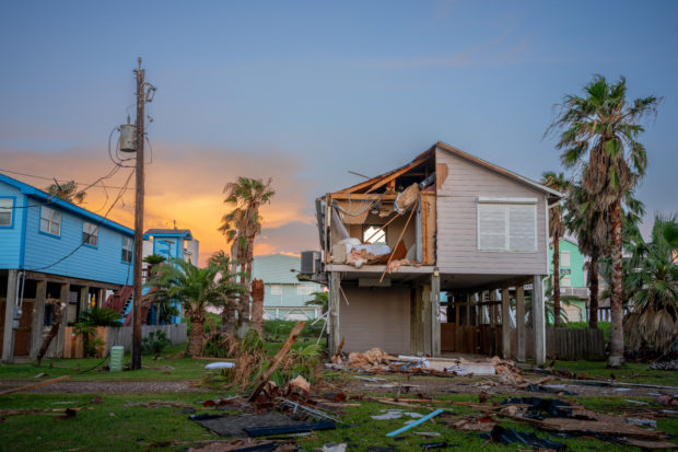
TOPSHOT – Mike Isbell (top) looks through his belongings after his home was destroyed in Surfside Beach, Texas, on July 8, 2024, after Hurricane Beryl made landfall. Hurricane Beryl made landfall July 8 in the southern US state of Texas, killing at least two people and causing millions to lose power amid dangerous winds and flooding, as some coastal areas remained under evacuation orders. (Photo by Mark Felix / AFP) (Photo by MARK FELIX/AFP via Getty Images)
Beryl hit the Texas coast in the early hours of Monday morning, knocking out power to more than a million residents. Some 2 million customers are still without power at the time of writing, according to USA Today.
At least eight deaths in Texas and Louisiana have also been linked to the storm, with dangerous flood conditions expected throughout the next several days. (RELATED: Footage Shows Suspected Tornado Destruction From Hurricane Beryl)
Republican Louisiana Gov. Jeff Landry declared a state of emergency following the storm to “allow parishes affected by Beryl to utilize state resources as we begin the recovery process,” he said in a statement. “We continue to remain in contact with our first responders and local officials and will assist them in every step of the way.”
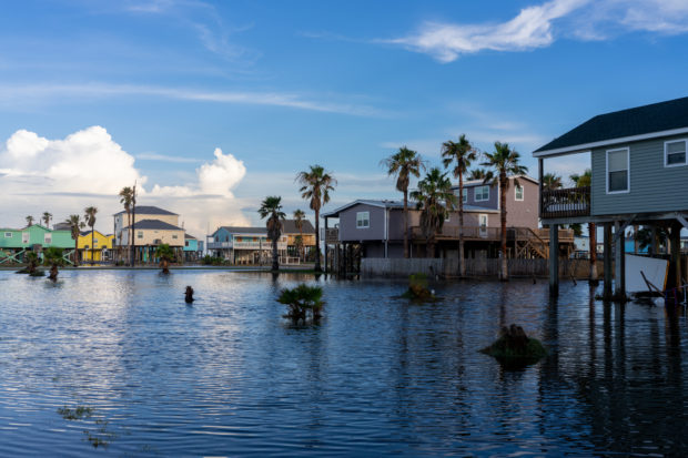
SURFSIDE BEACH, TEXAS – JULY 08: Homes are surrounded in floodwater after Hurricane Beryl swept through the area on July 08, 2024 in Surfside Beach, Texas. Tropical Storm Beryl developed into a Category 1 hurricane as it hit the Texas coast late last night. (Photo by Brandon Bell/Getty Images)

FREEPORT, TEXAS – JULY 08: A mobile is collapsed over on shore after Hurricane Beryl swept through the area on July 08, 2024 in Freeport, Texas. Tropical Storm Beryl developed into a Category 1 hurricane as it hit the Texas coast late last night. (Photo by Brandon Bell/Getty Images)
FREEPORT, TEXAS – JULY 08: A home is severely damaged after Hurricane Beryl swept through the area on July 08, 2024 in Freeport, Texas. Tropical Storm Beryl developed into a Category 1 hurricane as it hit the Texas coast late last night. (Photo by Brandon Bell/Getty Images)
Shortly after issuing their final notice on Beryl, the NHC alerted Americans to a small low-pressure system just off the southern Atlantic coast. Though there is a low chance of the system developing into a major storm, it could send some “disorganized showers and thunderstorms” to Florida, Georgia, and the Carolinas. (RELATED: Get Ready For A Category 6 Hurricane, But Not In The Way You Think)
Remember to always check your local weather forecast!