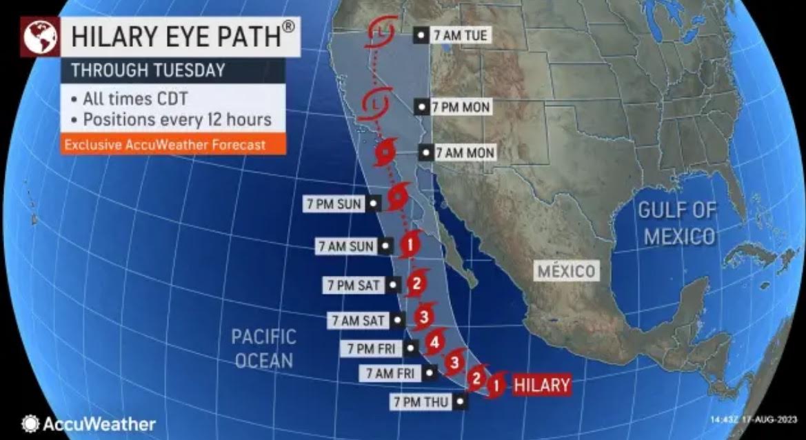
Hilary is on her way to do some damage to the Southwest.
Hurricane Hilary is currently churning in the Eastern Pacific near Mexico.
On Wednesday Hilary was a tropical storm but by Thursday morning, it strengthened into a Category 1 hurricane with sustained winds of 75 mph, AccuWeather reported.
Hilary is expected to strengthen to a Category 4 by Friday.
The storm will lose intensity and hit Southern California as a tropical storm by Saturday night or Sunday morning. San Diego, Orange County, and Los Angeles are bracing for gusty winds (70 mph) and flooding.
This is a rare event for Southern California.
Southern California is on alert for flash flooding, mudslides, damaging winds, and high surf.
AccuWeather reported:
A recently formed tropical system has become Hurricane Hilary and is forecast by AccuWeather meteorologists to wander close enough to the southwestern United States to raise the likelihood of torrential rain and the potential for major flash flooding beginning this weekend and lasting into next week.
The system was dubbed a tropical storm on Wednesday morning when it developed maximum sustained winds of 40 mph. As of early Thursday morning, it was found to have strengthened to a Category 1 hurricane with sustained winds of 75 mph. The system has undergone rapid intensification with winds increasing 35 mph in 24 hours or less and was located less than 600 miles to the south of the southern tip of Mexico’s Baja peninsula. The latest data continues to indicate strengthening with winds of 85 mph as of the midday hours on Thursday, local time.
Hilary is forecast by AccuWeather’s tropical weather team to become a major (Category 3) hurricane and peak as a Category 4 on the Saffir-Simpson Hurricane Wind Scale while spinning just off the southern tip of Mexico’s Baja peninsula this weekend. A Category 3 hurricane has sustained winds of 111-129 mph, while a Category 4 has winds of 130-156 mph.
More on Hurricane Hilary from CBS 8 San Diego:
